Teams Like This
The Amazon Basin is recognized and valued not just for its rich tropical forests, but also for its role as the world’s greatest and most diverse freshwater system. These aquatic ecosystems are foundations for life in Amazonia, critical not only to biodiversity but also for sustaining major fisheries and transportation industries and providing water and other aquatic resources for 30 million Amazonian residents. However, these ecosystems are under threat from mismanaged fisheries, infrastructure development, and climate change.
OUR APPROACH: This team synthesized all available relevant data on infrastructure, water, wetlands and fisheries to examine threats across the entire basin. With the results of this working group, land managers can use these results to make better, more informed decisions about development and conservation in the river basin.
Insights on Fish Migration Could Help Management
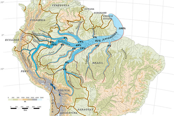
Exciting research from this working group confirms that the dorado catfish has the longest freshwater fish migration. From the Amazon estuary to their breeding grounds near the Andes, their journey spans 11,600 kilometers and takes 1-2 years to complete. These novel findings will be used to inform more effective fisheries and integrated water basin management in the Amazon.
GIS Roadmap for Conservation
The team produced a geographic information system (GIS) roadmap to help guide conservation efforts at a large scale in the Amazon River Basin. This new tool is scalable depending on user needs, and creates a classification system for the many rivers, estuaries, and basins. Overall, dynamically mapping natural resources and infrastructure impacts is a to support conservation and monitoring.
Amazon Waters Initiative
The Amazon Waters Initiative (AWI) is a call to action to conceptualize the vast, interconnected Amazon River Basin as a single aquatic ecosystem. The AWI seeks to build a network of alliances that will support conservation and management actions focused on maintaining the integrity of this complex river system.

“This new tool will enable scientists and governments to monitor development initiatives across the Amazon basin and help guide policy to minimize the environmental impact of these activities.”
– Michael Goulding, Project co-Leader
This data article presents a GIS framework that was developed especially for the analysis, management and monitoring of aquatic systems in the Amazon Basin.
The KNB database that contains the data associated with “A spatial river basin framework for Amazonian aquatic conservation.”
In this paper published in Scientific Reports, the team found that the migration distances of the Amazonian goliath catfishes are the longest strictly freshwater fish migrations in the world.
The Amazon Waters Initiative is a Wildlife Conservation Society project that spawned from the work of this SNAPP team.
A spatial framework for the conservation of aquatic ecosystems in the Amazon-Orinoco-Guianas Region.
Wildlife Conservation Society Amazonia
Wildlife Conservation Society
Wildlife Conservation Society
Instituto Nacional de Pesquisas da Amazônia
Wildlife Conservation Society
Wildlife Conservation Society
University of California-Santa Barbara
Northeastern University
Universidade Federal do Pará
Universidade Federal do Rio Grande do Norte
Instituto Nacional de Pesquisas da Amazônia
Universidade Federal do Pará
Wildlife Conservation Society
Pollination Group
University of California-Santa Barbara
Virginia Polytechnic Institute and State University (Virginia Tech)
University of California-Santa Barbara
Grupo de Análisis para el Desarrollo en el Perú
Fundação Vitória Amazônica
Universidade Federal de Vicosa
Instituto de Estudios Peruanos
Universidade Federal do Rio Grande do Sul
Universidade Federal do Pará
The Nature Conservancy
Instituto Mamirauá
Universidade Federal do Rio Grande do Sul
Instituto Nacional de Pesquisas da Amazônia
Universidade Federal do Pará
Instituto Chico Mendes de Conservação da Biodiversidade