Teams Like This
The Orinoquía region of Colombia, the second largest savanna system in South America, faces an agricultural development boom that could threaten biodiversity and ecosystem services. Producer organizations have teamed up with scientists and conservation planners to help the government evaluate the impacts of land use change their consequences for nature and people.
OUR APPROACH: This team will collaborate with partners and stakeholders to synthesize data related to ecosystem services and track the potential development in the areas of land-use, digital soil mapping, biodiversity and hydrology.
Datasets and Maps of Biodiversity and Soil
The team created a data set of vertebrate species and plants associated with different crops in the Orinoquía Region, as well as detailed soil carbon and land-use maps that are available on the web at their Orinoquía Dashboard. These data sets and maps will inform future land-use planners on how to work with the environment rather than to disregard it, while also developing the region.
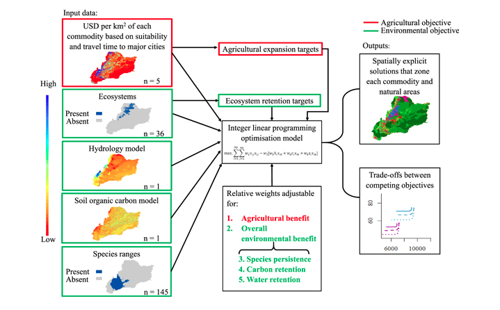
A Decision Support Framework
The team recognizes that land-use change is inevitable in under-developed regions, such as the Orinoquía, so they developed a framework that takes into account competing economic and environmental objectives in order to suggest action plans. Through using spatial analysis, the team can address agricultural production value, biodiversity conservation, and ecosystem services retention within their framework. The two categories of outputs of the framework are spatially explicit solutions that zone each commodity and natural areas, and trade-off analyses of competing objectives.

“This work demonstrates the power of existing data and knowledge for developing innovative approaches to help decision-makers pursue development measures and maximize ecosystem services.”
– Mayesse Da Silva, Project co-leader
This study estimates the soil organic carbon stock in the topsoil of the Eastern Plains of Colombia as agricultural and pastureland expansion continues to exert increasing pressure on the structure and ecological processes of its savannahs.
This peer-reviewed research paper provides a general methodological framework for hydrological analysis at macro-basin scale with a focus on the savanna ecosystems in Colombia’s Orinoquía region, a conservation area with significant plans for agro-industrial expansion.
In this piece published in Environmental Research Letters, the authors present a land-use planning framework to be used in relatively intact areas where development is inevitable, in order to minimize impacts on the environment.
A team created website where project components have been published and will continue to be published as they gain more permission to share data.
Wildlife Conservation Society
Spatial Informatics Group
International Center for Tropical Agriculture (CIAT)
The Nature Conservancy
University of Queensland
The Nature Conservancy
Wildlife Conservation Society
Wildlife Conservation Society
Colombia National Planning Department