How can connectivity in the Amazon Basin be maintained to support human well-being, wildlife, and the environments on which they depend?
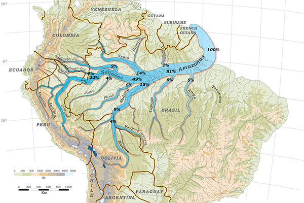
The Amazon Basin is recognized and valued not only for its rich tropical forests, but also for its role as the world’s greatest and most diverse freshwater system. Aquatic ecosystems are critical foundations for life in Amazonia, supporting biodiversity, major fisheries, and transportation industries, as well as providing water and other aquatic resources to 30 million Amazonian residents. However, these ecosystems are under threat from mismanaged fisheries, infrastructure development, and climate change.
OUR APPROACH: The team synthesized all available, relevant data on infrastructure, water, wetlands, and fisheries to examine threats across the entire basin. Land managers can use these results to make better, more informed decisions about development and conservation in the river basin.
Team Status:
Completed
Results
Insights on Fish Migration Could Help Management
Exciting research from this working group confirms that the dorado catfish has the longest freshwater fish migration. From the Amazon estuary to their breeding grounds near the Andes, their journey spans 11,600 kilometers and takes 1-2 years to complete. These novel findings will be used to inform more effective fisheries and integrated water basin management in the Amazon.
GIS Roadmap for Conservation
The team produced a geographic information system (GIS) roadmap to help guide conservation efforts at a large scale in the Amazon River Basin. This new tool is scalable depending on user needs, and creates a classification system for the many rivers, estuaries, and basins. Overall, dynamically mapping natural resources and infrastructure impacts is a to support conservation and monitoring.
Amazon Waters Initiative
The Amazon Waters Initiative (AWI) is a call to action to conceptualize the vast, interconnected Amazon River Basin as a single aquatic ecosystem. The AWI seeks to build a network of alliances that will support conservation and management actions focused on maintaining the integrity of this complex river system.
Impacts
“This new tool will enable scientists and governments to monitor development initiatives across the Amazon basin and help guide policy to minimize the environmental impact of these activities.”